Overview
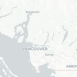
Clinton-Glenwood is listed in geographic databases as a community in British Columbia, with coordinates placing it within the Greater Vancouver metropolitan area, in or near the city of Surrey. The name may refer to a neighbourhood or combined locality rather than a formally incorporated municipality — verify the exact boundaries with local or provincial authorities before your visit.
The surrounding region is one of the most accessible parts of British Columbia, sitting close to major transit corridors, the US border at Peace Arch, and the farmland and river landscapes of the Fraser Valley. Visitors using this area as a base have quick access to downtown Vancouver, Langley, and Abbotsford.
Because this is primarily a residential suburban area, it does not have a concentrated tourist district. Travellers typically come here to visit friends or family, use it as a cost-effective accommodation base, or pass through en route to destinations farther east in the Fraser Valley or south toward the US border.
Before You Go
Visas and Entry
Canada's entry requirements depend on your nationality, purpose of visit, and how you arrive. For current rules — including Electronic Travel Authorization (eTA) and visa requirements — check TravelerPulse's Visas section and the official Immigration, Refugees and Citizenship Canada website.
What to Pack
British Columbia's Lower Mainland has a temperate oceanic climate. Summers (June–August) are warm and relatively dry; winters are mild but wet and grey. A waterproof layer is useful at most times of year. If you plan to venture into the Fraser Valley or mountains, layer appropriately.
Health and Insurance
Canada has a publicly funded healthcare system, but it does not cover non-residents. Comprehensive travel health insurance is strongly recommended before arrival. Confirm your coverage details with your insurer.
Getting There
By Air
The nearest major airport is Vancouver International Airport (YVR) in Richmond, approximately 30–40 km from the coordinates associated with Clinton-Glenwood depending on traffic. YVR is a major hub with direct connections across North America, Europe, and Asia.
By Road
The area is accessible via Highway 10 and the broader Trans-Canada Highway (Highway 1) network. From downtown Vancouver, expect roughly 30–50 minutes by car depending on traffic and the precise destination. The Massey Tunnel or Alex Fraser Bridge can be used to cross the Fraser River.
By Public Transit
TransLink, Metro Vancouver's regional transit authority, operates bus and SkyTrain services throughout Surrey and the surrounding region. The SkyTrain's Expo Line reaches Surrey Central and King George stations, with bus routes extending into outlying neighbourhoods. Check the TransLink website (translink.ca) for current routes, fares, and schedules.
Getting Around
Within the immediate suburban area, a personal vehicle or rideshare service is the most practical option, as land use is spread out and walking between points of interest is not always feasible. TransLink buses connect surrounding communities, though frequency and coverage vary by route — verify current schedules on the TransLink website.
Rideshare services (Uber, Lyft) and traditional taxis operate throughout Metro Vancouver including Surrey. Cycling infrastructure exists along some corridors in Surrey; verify local trail and lane availability through the City of Surrey's official website.
Things to See & Do
Because Clinton-Glenwood as identified by its coordinates sits within Greater Vancouver's suburban fabric, its immediate surroundings are primarily residential. However, the broader region offers considerable options within a short drive.
Natural Areas and Parks
- Redwood Park (Surrey) — A rare stand of old-growth redwoods planted in the early 20th century, with walking trails; verify opening hours locally.
- Brookswood and Otter Regional Park (Langley) — Trails through forest and open meadow.
- Fraser River estuary trails — Several access points along the river offer birdwatching and walking.
Day Trips
- Downtown Vancouver (30–50 min by car or SkyTrain) offers world-class museums, Stanley Park, Granville Island, and the waterfront.
- The Fraser Valley to the east features farm stands, wineries, and agri-tourism, especially around Langley and Abbotsford.
- White Rock, on the Semiahmoo Bay, offers a seaside promenade and pier a short drive south.
Food & Drink
The Surrey and Greater Vancouver area has an exceptionally diverse food scene reflecting one of Canada's most multicultural populations. South Asian cuisine (particularly Punjabi) is especially prominent in Surrey, and you'll find a wide range of restaurants along major commercial corridors such as 72nd Avenue, King George Boulevard, and Fraser Highway.
For specific restaurant recommendations in the Clinton-Glenwood vicinity, consult current reviews on Google Maps or Yelp, as individual establishments open and close frequently and verified current hours are best confirmed directly. Supermarkets, grocery stores, and convenience shops are plentiful throughout the suburban area.
Note that British Columbia has licensed restaurants and pubs; the legal drinking age is 19. Cannabis is legal for adults 19+ and sold at licensed retailers.
Practical Information
Emergency Services
In any emergency in Canada, dial 911 for police, fire, or ambulance.
Money
Most businesses accept major credit and debit cards. ATMs are widely available. Tipping is customary in restaurants (15–20% is standard) and for taxi or rideshare drivers.
Connectivity
Mobile network coverage (Rogers, Telus, Bell, and regional carriers) is strong throughout Metro Vancouver. Prepaid SIM cards are available at airports, convenience stores, and carrier retail locations. Public Wi-Fi is available in many libraries, malls, and transit stations.
Local Government Reference
For community-specific information, the City of Surrey (surrey.ca) is the relevant municipal authority for much of this area. Verify jurisdiction locally if needed.
Safety
The Greater Vancouver suburban area is generally safe for travellers. Standard urban precautions apply: be aware of your surroundings, secure valuables in your vehicle out of sight, and keep an eye on belongings in crowded public spaces.
British Columbia has experienced significant issues with opioid-related drug poisonings in recent years, primarily affecting vulnerable populations in specific urban areas. Travellers are not generally at elevated risk but should be aware of the public health context. Naloxone kits are available free of charge at many pharmacies in BC.
Road conditions can deteriorate in winter, particularly if you plan to travel east into the Fraser Valley or north into the mountains. Check DriveBC (drivebc.ca) for current road and weather alerts before driving.