Translate
Overview
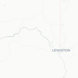
Lewiston sits at the confluence of the Snake and Clearwater rivers in the Idaho Panhandle, directly across from Clarkston, Washington. At roughly 738 feet above sea level, it holds the distinction of being Idaho's lowest-elevation city, which gives it a notably milder, drier climate than much of the state — warm summers and relatively mild winters with minimal snowfall.
The city's roots are tied directly to the Lewis and Clark Expedition, which passed through the area in 1805 and 1806. Lewiston later became Idaho's first territorial capital in 1863, though that designation was moved to Boise the following year. Today the city functions as a regional hub for agriculture, healthcare, and outdoor recreation, with roughly 32,000 residents.
Lewiston is perhaps best known among outdoor travelers as a gateway to Hells Canyon — the deepest river gorge in North America — and to the Clearwater National Forest. The confluence of two major rivers also makes it a practical inland port, connected to the Pacific Ocean via a system of navigable waterways along the Snake and Columbia rivers.
Before You Go
Lewiston is a domestic U.S. destination. International visitors should review entry requirements through TravelerPulse's Visas section and consult the U.S. Citizenship and Immigration Services (USCIS) website or the U.S. embassy in their home country before traveling.
Climate
Lewiston's location in a river valley produces a semi-arid climate. Summers are warm and sunny, with temperatures frequently climbing into the 90s°F (low-to-mid 30s°C) in July and August. Spring and fall are pleasant for hiking and river activities. Winter is mild by Idaho standards — snow is infrequent in the valley bottom — but conditions in the surrounding mountains and canyons can be unpredictable.
What to Pack
- Sunscreen, sunglasses, and a hat for summer visits
- Layers for spring and fall; mornings and evenings cool quickly
- Sturdy hiking boots if you plan to explore canyon or forest trails
- A reusable water bottle — canyon hikes can be hot and exposed
Practical Prep
Services in Lewiston are adequate for a small regional city. Fuel, groceries, pharmacies, and a hospital are all available. If you are planning to venture deep into Hells Canyon or the Clearwater backcountry, stock up on supplies and check road and river conditions before departure.
Getting There
By Air
Lewiston–Nez Perce County Regional Airport (LWS) is a small commercial airport located within the city. It offers scheduled service to regional hubs; verify current routes and airlines directly with the airport or booking platforms, as service can change.
By Road
US-12 connects Lewiston westward toward the Tri-Cities, Washington, and eastward along the Clearwater River corridor toward Missoula, Montana — a particularly scenic route. US-95 provides a north–south connection through Idaho. Spokane, Washington, is approximately 100 miles to the north and is the nearest large city with a major airport (GEG).
By Bus
Intercity bus service (including Greyhound connections) has historically operated through the region, but schedules and stops change. Verify current options locally or through national carrier websites before your trip.
By Boat
Lewiston is the furthest inland commercial port on the West Coast, accessible from the Pacific Ocean via the Columbia–Snake River waterway system. This is primarily a commercial shipping route, not a practical option for most leisure travelers, though jet boat and tour operators use the rivers recreationally.
Getting Around
Lewiston is a car-dependent city, and having your own vehicle or a rental is strongly recommended, especially for reaching Hells Canyon, trailheads, or the neighboring city of Clarkston, Washington, across the river.
The city itself is compact enough that the downtown area and riverfront can be explored on foot or by bicycle. A paved trail system runs along the Snake and Clearwater rivers and connects to Clarkston via the Lewiston Levee Parkway, which is popular with cyclists, joggers, and walkers.
Local public transit options are limited; verify current route and schedule information with the local transit authority. Rideshare app availability may be limited compared to larger cities — confirm before relying on it.
Things to See & Do
Hells Canyon
The most dramatic draw in the region, Hells Canyon is deeper than the Grand Canyon and straddles the Idaho–Oregon border along the Snake River. Several jet boat tour operators based in Lewiston and Clarkston offer guided excursions into the canyon. Verify tour operators, pricing, and seasonal availability locally or through the Hells Canyon National Recreation Area (managed by the U.S. Forest Service).
Lewiston Levee Parkway
A multi-use paved trail running for several miles along both the Snake and Clearwater riverbanks. It's free to use and accessible to walkers, joggers, and cyclists year-round. The trail connects to Clarkston's trail system, making for an enjoyable cross-state excursion.
Luna House Museum
Operated by the Nez Perce County Historical Society, the Luna House Museum covers regional history from the Nez Perce people through the settlement era and beyond. Hours and admission details should be verified directly with the museum.
Clearwater and Snake River Recreation
Fishing, kayaking, and rafting are popular on both rivers. The Clearwater River is particularly well regarded for steelhead and salmon fishing. Licenses and regulations are managed by Idaho Fish & Game — check their official website for current rules before fishing.
Nez Perce National Historical Park
While the park's main visitor center is located in Spalding, Idaho (about 12 miles east of Lewiston), it is an easy and meaningful day trip. The park interprets the history and culture of the Nez Perce Nation across dozens of sites in the region.
Food & Drink
Lewiston has a modest but functional dining scene typical of a small regional city. Locally owned restaurants, diners, and cafés are present alongside national chains. The downtown corridor and the area near the river tend to have the highest concentration of independent eateries.
The region produces wheat, legumes, and other agricultural products, and the broader Pacific Northwest wine and craft beer culture has some influence here. A small number of local breweries and wine-tasting rooms have opened in the Lewiston–Clarkston Valley; verify current businesses locally as the scene evolves.
For a broader dining selection, the twin city of Clarkston, Washington, just across the river, adds additional options within easy driving or walking distance.
Practical Information
Emergency Services
For any emergency in the United States, dial 911. St. Joseph Regional Medical Center provides hospital services in Lewiston.
Connectivity
Cell coverage is generally reliable within Lewiston proper. Coverage can drop significantly in canyon terrain or remote forest areas — plan accordingly if hiking or boating into the backcountry.
Money
ATMs and bank branches are available throughout the city. Credit cards are widely accepted at most businesses.
Time Zone
Lewiston observes Pacific Time (PT) — UTC−8 in winter, UTC−7 during Daylight Saving Time. Note that neighboring Clarkston, Washington, is in the same time zone, but parts of Idaho east of the Clearwater use Mountain Time — worth noting if you are driving east along US-12.
Safety
Lewiston is generally considered a safe small city. Standard urban precautions apply — be aware of your surroundings, secure valuables in your vehicle, and avoid leaving luggage visible in parked cars.
Outdoor safety is a more significant consideration. Hells Canyon and the surrounding wilderness are remote and can be extremely hot in summer. Rattlesnakes are present in canyon and dry grassland habitats — watch where you step and where you place your hands on rocks or logs. River currents on the Snake and Clearwater can be swift and powerful; always wear a life jacket when on the water.
If hiking in remote areas, inform someone of your plans and expected return, carry extra water and food, and check weather forecasts. Cell service is unreliable outside the city and river valley.